Urban Extension Road-II (UER-II): Route, History, Phases, and Current Status
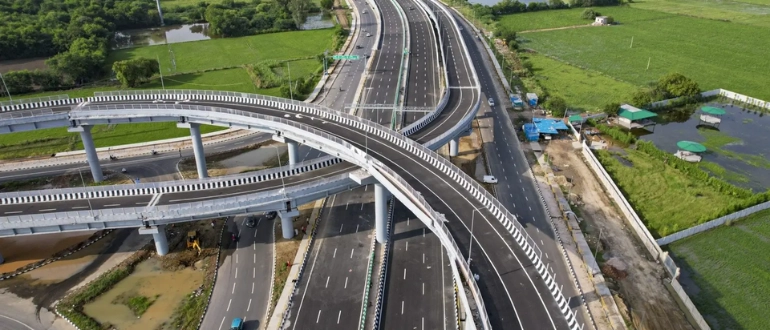
Urban Extension Road-II, officially known as NH-344M, is a 75.7 km long, 6-lane grade-separated expressway in the Delhi NCR region. It also has 6 additional service lanes running alongside the main carriageway, making it a total 12-lane corridor. The expressway forms a semi-circular route along the western side of Delhi, passing through major areas including Rohini, Mundka, Najafgarh, and Dwarka.
The expressway starts from National Highway 44 (NH-44) at Alipur in North Delhi and ends at the Dwarka Expressway near Shiv Murti, Mahipalpur, adjacent to the IGI Airport. The main corridor is 38.1 km long. It also has two additional link road spurs, a 29.6 km spur from Bawana Industrial Area to Sonipat in the northwest, and a 7.5 km spur from Najafgarh to the Bahadurgarh Bypass in the west.
UER-II plays a critical role in Delhi's ring road network. It forms a key part of the third ring road around Delhi when combined with the Chilla-Okhla Expressway, providing an important bypass route around the western and southwestern side of the city without entering the congested inner zones.
History of Urban Extension Road-II
2000: Conception The UER-II project was first conceived in the year 2000 as part of the Delhi Development Authority's NCR Transport Plan 2021. However, the project did not move forward for many years due to financial viability concerns and difficulties in land procurement.
2018: NHAI Takes Over In 2018, the National Highways Authority of India took over the implementation of UER-II Phase 1 after the DDA agreed to provide ₹4,000 crore as financial viability gap funding. Simultaneously, DDA undertook the construction of Phase 2 on its own. The project was included under the Bharat Mala Project by the Ministry of Road Transport and Highways, with NHAI as the implementing authority and URS Scott Wilson India Pvt Ltd in association with AECOM India Pvt Ltd appointed as consultants for the Detailed Project Report.
2025: Phase 1 Fully Operational The entire UER-II Phase 1 stretch of 75.7 km from Alipur to IGI Airport Shiv Murti became fully operational on 17 August 2025.
Construction of Urban Extension Road-II
The UER-II project was developed under the Bharat Mala Project by the Ministry of Road Transport and Highways, with NHAI as the proponent and implementing authority. The project was executed under the EPC model. The total civil construction cost is ₹4,557 crore, with a total capital cost including land acquisition and utility shifting of ₹7,582 crore.
Completed Development of UER-II
Completed phases of UER-II cover the main Alipur–Dwarka corridor and key spurs to Sonipat and Bahadurgarh, making it a major operational stretch of Delhi’s Third Ring Road. The Urban Extension Road-II (UER-II) is a 75.7 km (NH-344M) expressway.
Main Corridor: Alipur to Dwarka Sector 24 (38.1 km). This section connects NH-44 at Alipur to Dwarka Sector 24 passing through Bawana, Rohini, Mundka, Bakkarwala, and Najafgarh. It became operational in 2025.
Sonipat Connectivity Spur (29.6 km) connects Bawana Industrial Area to Sonipat Bypass in Haryana.
Bahadurgarh Connectivity Spur (7.5 km) connects Najafgarh and Dichaon Kalan to Bahadurgarh Bypass in Haryana.
Future Development of UER-II
Phase 2 (Under Construction) focuses on extensions from IGI Airport to Vasant Kunj and Tughlakabad with elevated corridors and bypass improvements.
Phases 3 & 4 (Planning) aim to complete the third ring road and connect to Chilla–Okhla Expressway and Eastern NCR.
Phase 5 (Planning) focuses on integration with FNG Expressway and outer NCR road networks.
Current Status of Dwarka Expressway
June 2025: Fully Operational The entire route of the Dwarka Expressway, from Shiv Murti at Mahipalpur to the Kherki Daula Toll Plaza, was completed and made fully operational in June 2025. The expressway was inaugurated in 2025 by Hon’ble Prime Minister Narendra Modi.
Future Extension: Shiv Murti to Sarai Kale Khan There is a plan to further extend the expressway by constructing an 18 to 20 km long tunnel from Shiv Murti to the Sarai Kale Khan Multi-Modal Transport Hub, which would significantly improve connectivity deeper into Delhi.
Economic Impact of UER-II
UER-II reduces congestion in central Delhi, improves freight movement, and enhances connectivity across NCR. It provides a high-speed bypass for commercial and industrial traffic, significantly reducing travel time between key logistics hubs. It boosts industrial activity in areas such as Bawana, Mundka, and Najafgarh by improving last-mile connectivity and reducing transportation costs for businesses. The expressway also strengthens links to major highways like NH-44 and NH-48, supporting smoother movement of goods across states. In addition, UER-II is driving strong real estate growth along the corridor, especially in emerging micro-markets near Dwarka, Rohini, and Najafgarh. Improved infrastructure is attracting both residential and commercial investments, making the region a key growth zone in Delhi NCR.
Also Read: Dwarka Expressway: Complete History, Route Map, Key Cities & Current Status
FAQs – Urban Extension Road-II (UER-II)
Q1. What is Urban Extension Road-II (UER-II)?Urban Extension Road-II (UER-II) is a 75.7 km (NH-344M) 6-lane expressway that starts from NH-44 at Alipur in North Delhi and ends at Dwarka Expressway near Shiv Murti, Mahipalpur (IGI Airport), forming part of Delhi’s Third Ring Road.
Q2. Where does UER-II start and end?It starts from National Highway 44 (NH-44) at Alipur in North Delhi and ends at the Dwarka Expressway near Shiv Murti, Mahipalpur, adjacent to the IGI Airport.
Q3. Is UER-II fully operational?Yes, Phase 1 of UER-II covering the entire 75.7 km stretch from Alipur to IGI Airport Shiv Murti became fully operational on 17 August 2025.
Q4. Which areas does UER-II pass through?UER-II passes through major areas including Rohini, Bawana, Mundka, Bakkarwala, Najafgarh, Dwarka, and the IGI Airport corridor.
Q5. What is the total length of UER-II?The main corridor of UER-II is 75.7 km long, with additional link road spurs increasing its overall connectivity across the NCR region.
Q6. What are the connectivity spurs of UER-II?UER-II includes two major spurs: a 29.6 km spur connecting Bawana Industrial Area to Sonipat in Haryana, and a 7.5 km spur connecting Najafgarh to the Bahadurgarh Bypass.
Q7. What are the future phases of UER-II?The future development of UER-II includes Phase 2, which connects IGI Airport to Vasant Kunj and Tughlakabad with elevated corridors and improved bypasses. Phases 3 and 4 aim to complete the full third ring road around Delhi by connecting to the Chilla–Okhla Expressway and eastern NCR routes. Phase 5 focuses on integration with the FNG (Faridabad–Noida–Ghaziabad) Expressway and other outer NCR road networks.
Q8. Who developed UER-II?The project is developed under the Ministry of Road Transport & Highways with NHAI as the implementing authority under the Bharatmala Project.
Q9. What is the impact of UER-II on Delhi NCR traffic?UER-II reduces congestion in central Delhi, improves freight movement, and provides faster connectivity between Delhi, Gurugram, Sonipat, and other NCR regions by offering a high-speed alternative bypass route.
Q10. Is UER-II connected to IGI Airport?Yes, UER-II connects directly to the Dwarka Expressway corridor near Shiv Murti, providing seamless access to IGI Airport and nearby transport networks.
Q11. What is the economic impact of UER-II?UER-II boosts industrial activity in Bawana, Mundka, and Najafgarh by improving logistics and reducing transportation costs. It also supports strong real estate and commercial development along the corridor, making it one of the key growth drivers in the Delhi NCR region.